BlueChart G3 Vision includes all the reliability, functionality and integrated Garmin and Navionics content of BlueChart g3 while adding even more exceptional features, such as high-resolution relief shading, to help you along your journeys.
Garmin 010C088400 Attributes
- Compatibility:Compatible With Chart Plotters
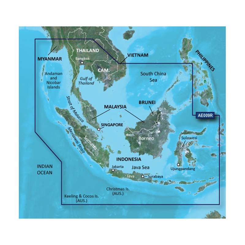
- Chart Coverage:VAE009R Singapore, Malaysia And Indonesia
- Storage:On SD/ Micro-SD Card
Garmin 010C088400 Features & Benefits
- Derived From Official Charts And Private Sources To Provide Navigational Aids, Spot Soundings, Depth Contours, Tides And Currents, And Detailed Harbors And Marinas
- Garmin Auto Guidance Technology Shows A Suggested Route To A Destination
- Depth Range Shading For Up To 10 Depth Ranges, Enables You To View Your Target Depth At A Glance
- Up To 1 Foot Contours Provide A More Accurate Depiction Of The Bottom Structure For Improved Fishing Charts And Navigation
- Shallow Water Shading Feature Allows For Depth Shading At A User-Defined Level To Aid In Navigation
- Unique 3D Views Like MarinerEye And FishEye Provide Additional Perspective Both Above And Below The Water Line
- High-Resolution Satellite Imagery Of Ports, Marinas, Bridges And Navigational Landmarks For Superior Situational Awareness
- Crystal-Clear Aerial Photography Shows Exceptional Detail Of Many Ports, Harbors And Marinas And Is Ideal When Entering Unfamiliar Ports
- Limited One Year Consumer Warranty
Garmin 010C088400 Warranties
- garmin-marine-warranty-policy.pdf
BlueChart g2 Vision HD - VAE009R - Sin/Mal/Indonesia - microSD/SD
Coverage:
The southwestern portion of the Malay Peninsula through Singapore and the eastern side of Sumatra Island. Also included are numerous detailed charts covering areas such as Kuantan, Mal., Jakarta, Indo., and Merak, Indo., as well as Christmas, Keeling, and Cocos Islands. General coverage of Java, Celebas, the southern half of Borneo and other surrounding islands east to Timor.
Our Premium Chart Offering
- Derived from official charts and private sources to provide navigational aids, spot soundings, depth contours, tides and currents, and detailed harbors and marinas
- Garmin Auto Guidance technology shows a suggested route to a destination
- Depth Range Shading for up to 10 depth ranges enables you to view your target depth at a glance
- Up to 1-foot contours provide a more accurate depiction of the bottom structure for improved fishing charts and navigation
- Shallow Water Shading feature allows for depth shading at a user-defined level to aid in navigation
- Unique 3D views like MarinerEye and FishEye provide additional perspective both above and below the water line
- High-resolution satellite imagery of ports, marinas, bridges and navigational landmarks for superior situational awareness
Auto Guidance
Auto Guidance technology quickly calculates a suggested route using your boat's dimensions and a suggested path to follow.
Depth Range Shading
Displays high-resolution Depth Range Shading for up to 10 depth ranges so you can view your designated target depth.
Detailed Contours
BlueChart g2 Vision HD features 1-foot contours that provide a more accurate depiction of bottom structure for improved fishing charts and enhanced detail in swamps, canals and port plans.
MarinerEye View
Provides a 3-D representation of the ocean floor as seen from below the waterline.
FishEye View
Provides a 3-D representation of the surrounding area both above and below the waterline.
High-resolution Satellite Imagery
High-resolution satellite imagery with navigational charts overlaid gives you a realistic view of your surroundings so you can navigate with a clear moving-chart representation of your boats position. Its our most realistic charting display in a chartplotter.
Aerial Photography
Crystal clear aerial photography shows exceptional detail of many ports, harbors and marinas and is ideal when entering unfamiliar ports.
Auto Guidance is for planning purposes only and does not replace safe navigation practices
This product may not be returned to the original point of purchase. Please contact the manufacturer directly with any issues or concerns. BlueChart g2 Vision provides the same rich detailed charts as BlueChart g2 to help you make the most of your equipment. In addition, g2 Vision also has a growing high... !!!!----
PRODUCT ID: 31034
SKU: NVN-31034
CSKU: CWR-31034
REWRITE: 42145-garmin-bluechart-g2-vision-hd-vae009r
MPN: 010-C0884-00
UPC: 753759070649
ASIN:
WSKU:
SSKU:
KSKU: GCM010C088400
GSKU:
MSKU:
LSKU:
NAME: Garmin BlueChart g2 Vision HD - VAE009R - Sin/Mal/Indonesia - microSD/SD
NAME_EX: GARMIN VAE009R SIN/MAL INDONESIA G2 VISION SD
PTITLE: Garmin BlueChart g2 Vision HD - VAE009R - Sin/Mal/Indonesia - microSD/SD
TYPE: Cartography | Garmin BlueChart Vision Foreign
VENDOR: Garmin
Google Category: SOFTWARE > COMPUTER SOFTWARE > GPS MAP DATA & SOFTWARE
Amazon Category:
Amazon Title:
Google Title: BlueChart g2 Vision - Bay of Bengal to Kupang and Manado - Maps
Amazon Category:
Gtags:
GSpecs:

![Hidden Blade [307] [Extended Art] [Buy a Box] [Assassin's Creed] [Foil]](https://img.modeyrnbets.shop/67/4156/2025051218/hidden-blade-307-extended-art-buy-a-box-assassin-s-creed-foil.webp)